
Mountains of Madinah: The Peaks That Shaped Islamic History
Table of Contents
Mountains of Madinah: The Peaks That Shaped Islamic History
The Mountains of Madinah are far more than mere geological features; they are silent witnesses to the dawn of Islam. While pilgrims flock to the Prophet’s Mosque, these ancient peaks hold stories of battles, prayers, and the very foundation of the Muslim community. Understanding their names and locations isn’t just geography—it’s connecting with the physical landscape of the Seerah. This definitive guide will map the iconic Mountains of Madinah, delve into their profound historical significance, and show you how to appreciate their enduring legacy.
1. Why the Mountains of Madinah Matter
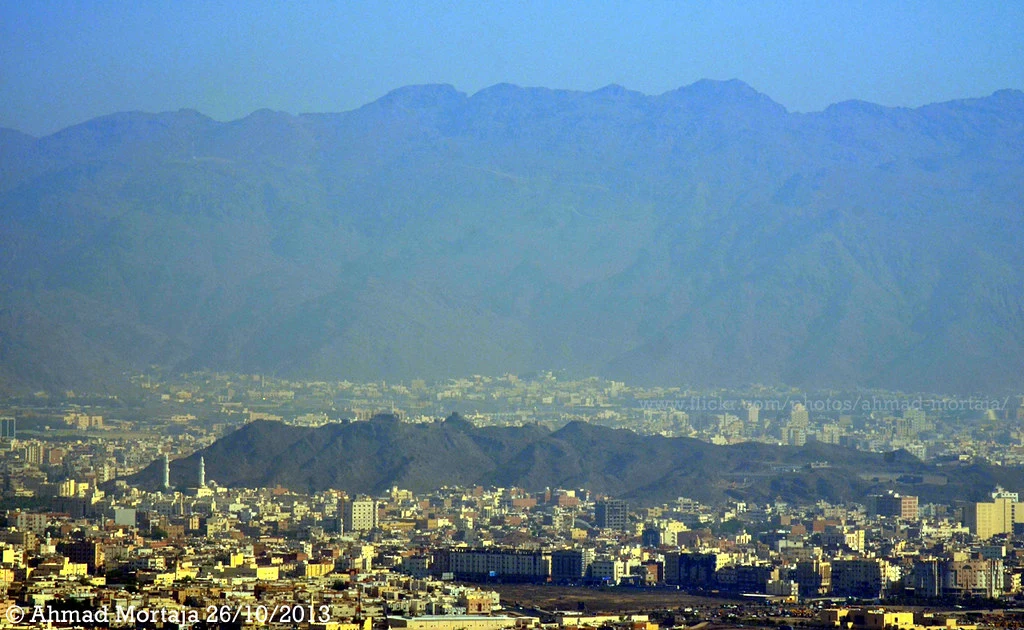
The Mountains of Madinah created a natural fortified basin for the city, offering protection and defining its early boundaries. They are frequently mentioned in Hadith and historical accounts, serving as landmarks for directions, sites for crucial events like the Battle of Uhud, and places of solitude and worship. Today, as the city expands, some peaks like Jabal Sala’ have been enveloped by urbanization, while others remain majestic sentinels on the horizon, reminding us of the city’s rich topographic tapestry.
2. The Northern Guardians: Uhud and Beyond
The northern range is the most historically charged. It is home to the beloved mountain of the Prophet (PBUH).
- Jabal Uhud: The most famous of the Mountains of Madinah, located about 5.5 km north of the Prophet’s Mosque. The site of the pivotal Battle of Uhud, it holds the graves of the martyrs. The Prophet (PBUH) said, “Uhud is a mountain that loves us and we love it.” (Sahih al-Bukhari).
- Jabal Thawr: (Not to be confused with the cave in Makkah) is approximately 8 km north.
- Jabal al-Rumah (Jabal ‘Aynain): About 5 km north. This is where the Prophet (PBUH) positioned his archers during Uhud.
- Jabal Thaniyat al-Wada’ (The Farewell Pass): Once a prominent hill 1.1 km north where travelers were bid farewell. It was later leveled during urban development.
- Jabal al-Rayah (Jabal Dhubab): About 1.5 km north, home to the historic Masjid al-Rayah.
3. Mountains Within the City: Sala’ and Sila’
Some Mountains of Madinah are now central urban landmarks.
- Jabal Sala’: Located in the northwest, this mountain was inhabited by tribes since the Prophet’s time and is now fully integrated into the city’s fabric. It has several connected ridges.
- Jabal Sila’: A smaller extension or peak near Jabal Sala’.
- Jabal al-Mustandir: A small black hill in the Da’udiyyah area to the north, which was also leveled in early development projects.
4. The Southern Sentinel: Mount ‘Eer
To the south, Jabal ‘Eer stands as a major landmark. It stretches about 5.5 km in length and is roughly 8 km from the Prophet’s Mosque. Rising about 300 meters, it is surrounded by smaller hills known as Dhalay’at al-Quba. Its prominent silhouette makes it a key visual marker for the city’s southern approach.
5. Historical Livelihoods: The Woodcutters of the Hills
The abundance of these mountains created numerous slopes and valleys (shi’ib) that filled with vegetation after rains. This supported a vibrant industry of grazing and woodcutting (ihtitab). The poor would gather firewood from the Mountains of Madinah to sell in the city, following the Prophet’s (PBUH) encouragement to seek halal sustenance.
A famous narration tells of a man who complained of poverty. The Prophet (PBUH) instructed him to buy an axe with a portion of his last money. The man then gathered wood, sold it, and thus established a sustainable livelihood, earning the Prophet’s blessings for his honest work (Al-Taratib al-Idariyyah). Companions like Salman al-Farisi (RA) also worked as woodcutters.
6. A Comprehensive Directory of Madinah’s Mountains
Given the sheer number of peaks, classical scholars have categorized them by direction. Here is a summarized directory based on historical texts like ‘Jibal Makkah wa al-Madinah’ by Al-Sulami and modern geodetic surveys (using 1985 aerial imagery and the Saudi National Geodetic Network).
| Direction | Notable Mountains (Examples) |
|---|---|
| North | Uhud, Thawr, al-Rumah, Thaniyat al-Wada’, al-Rayah, Waeerah, al-Hafya’ |
| North-East | Ti’ab (al-Khazzan), al-Tha’labi, Abu Zuraibah, al-Hayd |
| North-West | Sala’, Sila’, Bani ‘Ubayd, Habashi, Katanah |
| South | ‘Eer, al-Hazim, al-Aswad, al-Faridah, Dib’ |
| South-East | Qurayzah, al-Malasa’, al-Nadhiyah, Miytan |
| South-West | Jumaa’ Tadaru’, Makimun, ‘Adhm, al-Qudayyah |
| East | Taym, al-Fara’id, Rawdat ‘Atiyyah, al-Ghubbi |
| West | Jumaa’ Umm Khalid, al-Sahluj, al-Haram (The Red Mountain), al-Tays |
For a detailed geographic study, refer to research papers like “Al-Madinah al-Munawwarah: Iqtisadiyat al-Makan” by Dr. Omar Al-Faruq.
7. How to Explore the Mountains of Madinah Today
Exploring the Mountains of Madinah requires respect and preparation.
- Jabal Uhud: Easily accessible with a well-developed visitor area. It’s a site for prayer, reflection, and visiting the martyrs’ cemetery.
- City Mountains (Sala’): Can be viewed from various points in the city, often integrated into parks.
- Important Note: Many mountains are in rugged terrain. Always prioritize safety, ensure you have permission to access remote areas, and be mindful of private property. The best initial exploration is often visual, appreciating their profiles against the Madinah skyline as described in ancient and modern aerial imagery.
A Landscape Steeped in Faith
The Mountains of Madinah are immutable chapters in the city’s story. From the love the Prophet (PBUH) showed for Uhud to the humble woodcutters who earned their living from their slopes, these peaks are woven into the spiritual and social history of Islam. By learning their names and stories, we move beyond seeing a mere skyline to reading a sacred map—one that guides us to a deeper connection with the city of Allah’s Messenger (PBUH).
Internal Link: A Complete Guide to 7 Historical Mosques Sites in Madinah.
External Dofollow Links:
- Link to the Saudi Geological Survey for official maps and data: https://sgs.org.sa