
Exploring the Historic Routes of the Prophet: A Journey to ‘Ayn Abūd
Table of Contents
Exploring the Historic Routes of the Prophet: A Journey to ‘Ayn Abūd
The Allure of ‘Ayn Abūd
‘Ayn Abūd is not merely a location on a map 110 kilometers from Madinah; it is a portal to the past. Nestled within the majestic landscape west of Madinah, this area, centered around the well-known mountain, Jabal ‘Abūd, represents a critical chapter in the story of Islamic civilization. It sits astride the ancient migration and trade routes used by the Prophet Muhammad (peace be upon him) and his companions, serving as a vital waystation for travelers, armies, and caravans for centuries.
For the modern seeker of knowledge or the passionate explorer of history, understanding ‘Ayn Abūd is key to visualizing the journeys that shaped early Islam. This article will serve as your comprehensive guide, combining geographical insights, historical narratives, and expert analysis to bring this significant region to life.
The Geographic Significance of ‘Ayn Abūd
The core of this historic area is Jabal ‘Abūd, a mountain that acts as a central landmark. Its importance is intrinsically tied to the network of wadis (valleys) that surround it. this region is a prime example of a “watershed divide” or “maqsim al-ma'” (مقسم الماء).
This is the geographical line where rainwater divides, flowing into different catchment areas. In the ‘Ayn Abūd region, this divide determines whether water flows eastward or westward, creating the lifeblood for various valleys and, historically, for the travelers who depended on them.
Two major wadis originate here: Wādī Marrā al-A‘lā and Wādī Marrā al-Akhar. They converge at a point known as Al-Farīsh before diverging again—one heading towards Jabal ‘Abūd and the other south towards Wādī al-Qamīs. Ultimately, these waters feed into the larger Wādī Malal.
‘Ayn Abūd in Islamic History and Prophetic Tradition
This landscape is famously known as the “Ṭarīq al-Anbiyā'” (Way of the Prophets). The Prophet Muhammad (peace be upon him) traversed these very paths during several expeditions (ghazawāt) and his journeys to visit tribes. The region was part of the vital corridor linking Madinah to Yanbu’ and beyond.
The presence of waystations (barīd, pl. barādīd) underscores its logistical importance. A barīd was traditionally a distance of about 20 km, marking the points where travelers might rest. The discussion around where exactly to shorten prayers (qaṣr al-ṣalāh) during travel often referenced these four-stage journeys from Madinah.
Ibn Maqbil al-Laythī, a historical figure cited in sources like Wafā’ al-Wafā by al-Samhūdi, is famously associated with this land, having described the appearance of a spring in the foothills of ‘Abūd. His poetry and accounts are among the threads connecting us to the region’s past identity.
Decoding the Ancient Waystations: Al-Mafarrāt to As-Sadār
Based on the descriptions from former residents of area, we can reconstruct the key stops on this historic route leaving Madinah towards the west:
- Al-Mafarrāt (المفرّات): The first waystation. Its exact location is debated, but its name evokes the “joy” (farah) of pilgrims nearing Madinah. It contained landmarks like Bi’r al-Ḥafīrah (the well of the pit), also attributed to Caliph Umar ibn Abdulaziz.
- Sharq Jabal ‘Abūd (شرق جبل عبود): The second waystation, literally “East of Mount ‘Abūd.” This places ‘Ayn Abūd directly on the historic stage.
- Al-Marāghah (المراغة): The third waystation, located on the old road to Yanbu’.
- Al-Masījīd (المسيجيد) & As-Sadār (السدار): The fourth area of stopovers.
These waystations were not arbitrary; they were strategically placed at water sources and defensible locations, supporting the movement of people and goods.
The Hydrology of a Desert Oasis: How ‘Ayn Abūd Exists
A key question arises: why is this region rich in springs when its geology features igneous (volcanic) rocks, which are typically poor at storing water? a geography expert, clarifies this paradox.
The water in the ‘Ayn Abūd area is not stored in vast underground aquifers within rock layers. Instead, it is retained within the alluvial sediments and deposits that fill the wadis and their tributaries. When rain falls on the mountains, it runs off quickly but gets trapped and stored in the gravel, sand, and soil of the valley floors. These natural reservoirs then feed the springs (‘uyūn), such as the famed ‘Aynayn (the two springs) at the confluence of Al-Ḥawrat.
This makes the location of settlements and waystations highly dependent on these specific hydro-geological conditions.
Notable Landmarks and Their Stories
- Jabal al-Aghwāt (جبل الأغوات): The “Mountain of the Servants/Guides.” It is said that aghawāt (servants or guides) would take pilgrims here to get their first, joyful glimpse of Madinah from a distance, hence its association with the Mafarrāt (place of joy) area.
- Bi’r al-Ḥafīrah: A historically significant well, constantly maintained and re-dug over generations, linked to the Umayyad caliph Umar ibn Abdulaziz.
- Wādī Abī Kabīr: A major valley whose headwaters begin near Sahmān/Samhān. Its waters eventually converge with other valleys like Dhāt al-Jaysh before flowing into the great Wādī al-‘Aqīq.
- Dhāt al-Jaysh (ذات الجيش): A location associated with a significant Islamic event: the revelation of the verses concerning Tayammum (dry ablution). It is linked to the incident of Sayyidah ‘Ā’ishah’s (رضي الله عنها) lost necklace, which led to the divine concession for using clean earth for purification when water is unavailable.
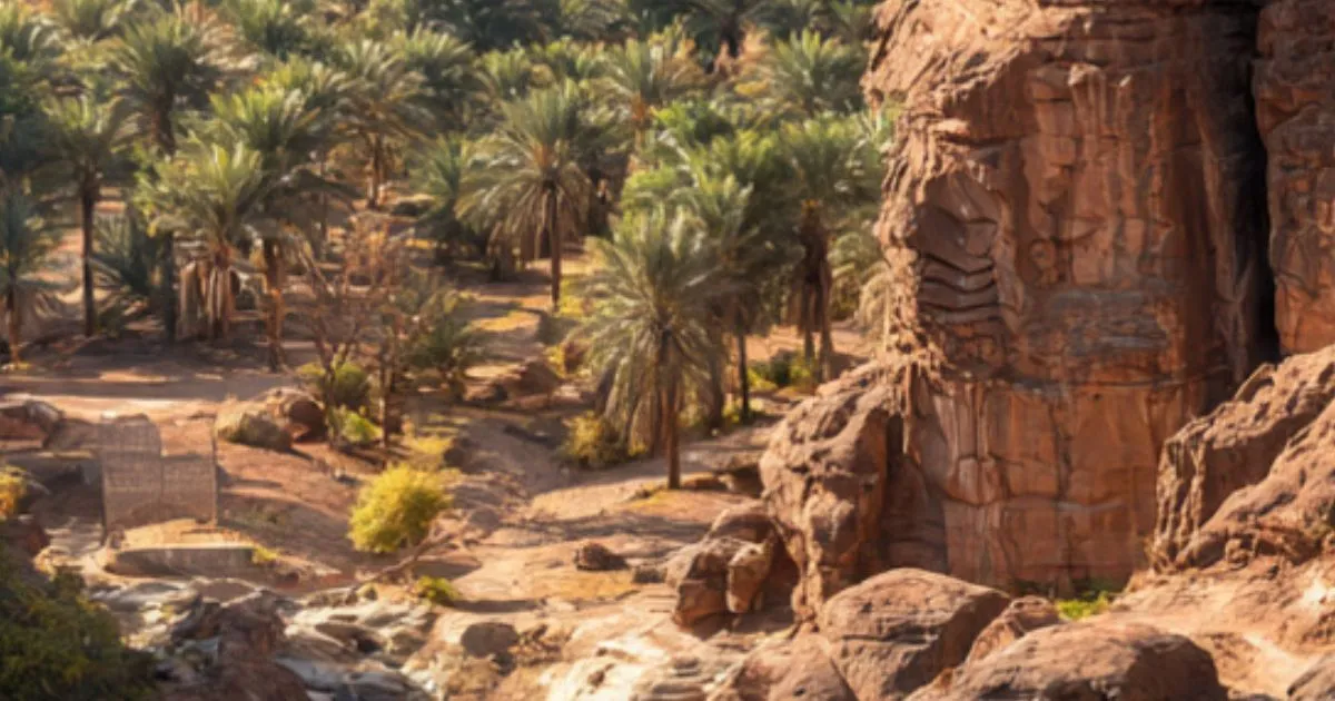
- ‘Aynayn at Al-Ḥawrat: these were two springs with clear ruins and evidence of old structures, possibly related to agricultural estates during the Umayyad era (e.g., Caliph Abdul Malik ibn Marwan). The area was known for numerous ancient inscriptions and rock art (nuqūsh).
Modern Exploration and Archaeological Potential
The area has ruins as late as the 1400s AH (1980s CE), point to a rich, untapped archaeological site. Areas like Qā‘ al-Sa‘diyyah, Zaydān hill, and the confluence at Al-Ḥawrat were mentioned as having remnants of stone structures, foundations, and what local Bedouins called “zirbān” (enclosures or ruins).
This presents a compelling case for systematic archaeological survey. The region of ‘Ayn Abūd could hold invaluable information about early Islamic settlement patterns, water management, and travel infrastructure. Protecting these sites from modern development is crucial for preserving this tangible link to the Prophetic era.
Conclusion: A Living Legacy
‘Ayn Abūd is far more than a forgotten desert stop. It is a testament to the deep connection between geography, history, and faith. By studying its mountains, valleys, and ancient wells, we don’t just learn about rocks and water; we trace the footsteps of the Prophet (ﷺ), understand the challenges of early Muslims, and uncover the ingenuity required to thrive in a harsh landscape.
The journey to uncover the full story of ‘Ayn Abūd continues. It calls to historians, geographers, archaeologists, and every Muslim interested in the physical landscape of our glorious heritage. It reminds us that history is not confined to books—it is etched into the very land we can still visit today.
Internal Links:
- Learn more about rivers of Madinah.
External Dofollow Links:
- For a detailed geographical study on the watersheds of the Hijaz region, see this research paper on ScienceDirect.
- Historical maps and references to ancient Arabian waystations can be found in the archives of Saudi Arabia’s Heritage Commission.