
The Rivers of Madinah: A Comprehensive Guide to Their History, Hydrology, and Modern Legacy
Table of Contents
The Rivers of Madinah: A Comprehensive Guide to Their History, Hydrology, and Modern Legacy
The Rivers of Madinah are not merely geographical features; they are arteries of history, pulsating with stories from the dawn of Islam. These valleys, or wadis, have witnessed the footsteps of the Prophet Muhammad (peace be upon him), his companions, and centuries of inhabitants, shaping the city’s physical and spiritual landscape. A common question arises: “How many rivers of Madinah are there?” While the city is renowned for a handful of famous names, the network is intricate, comprising several primary and secondary valleys. Furthermore, the phenomenon of flooding poses a timeless question: “Is the Medina River flooding a real concern?” This article delves deep into the heart of these ancient waterways, exploring their historical significance, hydrological behavior, and impressive modern transformation, providing a definitive guide to the Rivers of Madinah.
Introduction: The Lifelines of the City of the Prophet
Nestled in the Hejaz region of Saudi Arabia, Madinah’s existence has always been intrinsically linked to its water sources. The Rivers of Madinah, though seasonal, provided the water necessary for agriculture, settlement, and survival in the arid climate. Their names are etched into Islamic history through Hadith, classical texts, and the chronicles of early scholars like Ibn Shabah (173-262 AH). Understanding these valleys is key to understanding the city itself. This exploration covers their number, their profound historical and religious connections, and the ongoing balance between preserving their legacy and managing their power, particularly the ever-present risk of floods.
How Many Rivers of Madinah Are There? Classifying the Valleys
Addressing the core question, “How many rivers of Madinah are there?” requires a nuanced answer. The city is traditionally celebrated for a specific set of valleys, which can be classified into two clear categories:
- The Famous Rivers of Madinah (6): Wadi Al-Aqeeq (The Blessed Valley), Wadi Bathan, Wadi Rannuna, Wadi Mahzur, Wadi Qana, and Wadi Muzainib.
- The Lesser-Known Rivers of Madinah (4): Wadi Shadha, Wadi Al-Sirar, Wadi Jafaf, and Wadi Al-Areed.
Therefore, one can confidently state that there are at least ten significant Rivers of Madinah documented in historical sources. However, the most prominent, both in size and historical mention, are Wadi Al-Aqeeq, Wadi Bathan, Wadi Mahzur, and Wadi Qana.
Wadi Bathan: The River from the Canals of Paradise
Among the Rivers of Madinah, Wadi Bathan holds a place of exceptional distinction. It is a prominent and important landmark, also known to the people of Madinah as “Wadi Abu Jaidah.”
Historical and Religious Significance
The name Wadi Bathan is directly mentioned in Islamic tradition, elevating its status beyond a mere geographical entity. The 9th-century scholar Ibn Shabah reported in his “History of Madinah” that “Wadi Bathan is on a canal from the canals of Paradise.” Furthermore, in one of the most authoritative collections of Hadith, Sahih Al-Bukhari, it is recorded that the Prophet Muhammad (peace be upon him) performed ablution with water from this valley during the Battle of the Trench (Ghazwat al-Khandaq) in 5 AH (627 CE). This event forever sanctified its waters in the hearts of Muslims.
Course and Hydrology
The course of Wadi Bathan can be traced from the well-known Bathan Dam, where floodwaters initially gather. It then flows towards the Qurban area, passing near Al-‘Awali at the Mughassalat Al-Laqin area, then to Al-Madshuniyah. From there, it takes the Qurban road down to Al-Seeh, flows west of the Seven Mosques, and finally reaches the Al-‘Uyun area, where it converges with the more famous Wadi Al-Aqeeq in Zughabah. This confluence is a critical hydrological point in the city’s watershed.
Wadi Mahzur: A Tributary with a Legacy of Prophetic Law
One of the key tributaries feeding into the system of the Rivers of Madinah is Wadi Mahzur. Located east of Wadi Muzainib, it originates from Harrat Waqim in the east of Jabal Al-Malsa, situated approximately 25 km southeast of Madinah. The valley passes east of Al-‘Awali and through the lands of the Banu Quraizah—earning it the alias Wadi Quraizah—before heading northwest until it flows into Muzainib on the outskirts of Madinah, just before Muzainib itself flows into Bathan.
Wadi Mahzur was a primary water source for the farms of the Shouran area; its flooding was essential for replenishing the wells. Its historical importance is further cemented by its mention in several hadiths, where the Prophet (peace be upon him) established specific water rights.
Abu Malik bin Tha’labah bin Abi Malik reported from his father: “The Messenger of Allah (peace be upon him) ruled regarding Mahzur and the valley of Bani Quraizah that water is allowed to be retained up to the ankles. The upper beneficiary cannot withhold water from the lower one, but the lower one can hold it back.” Another narration, also via Umar bin Shabah, states: “The Messenger of Allah (peace be upon him) ruled regarding the flood of Mahzur that for the owners of palm trees, [they may retain water] up to the ankles, and for the owners of crops, up to the shoe straps. Then they must send the water to those below them.”
These rulings, made over 1,400 years ago, represent an early and sophisticated legal framework for water management, highlighting the practical challenges and solutions associated with the Rivers of Madinah.
Is the Medina River Flooding a Historical and Modern Concern?
The question, “Is the Medina River flooding a real concern?” has a resounding yes for an answer, both historically and in the modern era. These valleys are not gentle streams but powerful conduits for flash floods (seil) that can appear suddenly after heavy rainfall in the surrounding harrah (volcanic fields).
Historical Floods and the First Dams
The most famous historical account comes from the caliphate of Uthman ibn Affan (r. 23-35 AH/644-656 CE). It is reported that the city was nearly submerged by a devastating torrent from Wadi Mahzur, prompting Caliph Uthman to order the construction of a dam (radm) to protect the urban center. This event is a critical data point, proving that the management of the Rivers of Madinah has been a top priority for civic leaders since the first century of Islam.
Modern Flood Management and Statistics
In the 20th and 21st centuries, with urban expansion into former floodplains, the need for advanced management intensified. The Saudi government has undertaken massive engineering projects to answer the “flooding” question definitively.
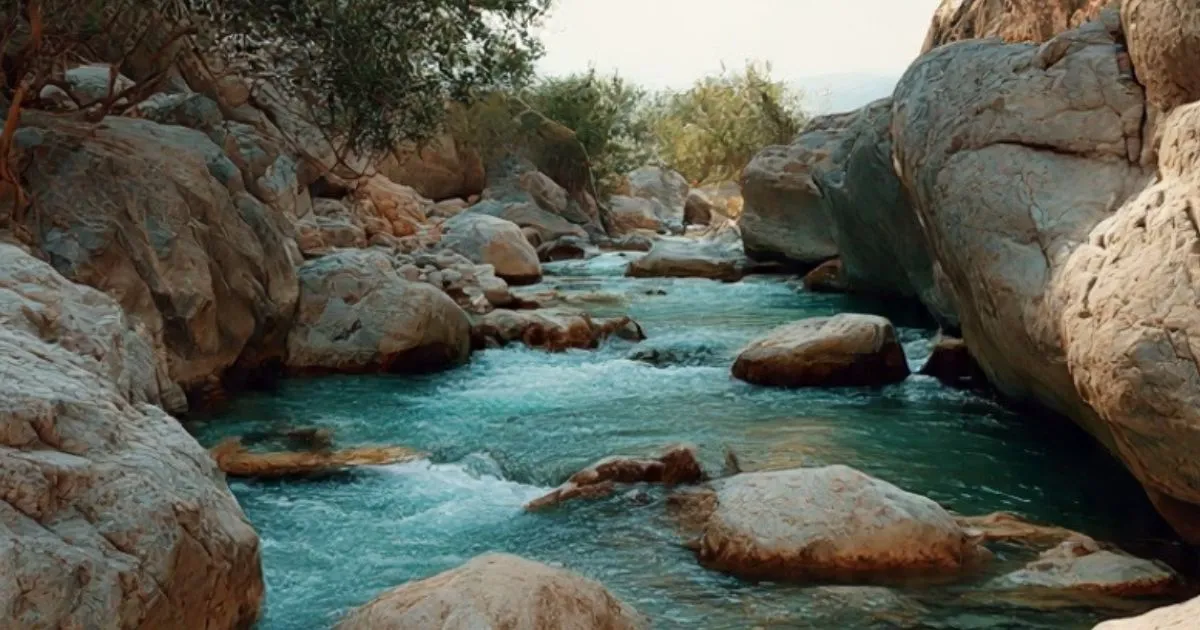
Wadi Qana: The Giant Among the Rivers of Madinah
Wadi Qana is arguably the largest and most historically rich of all the Rivers of Madinah. Its scale is such that its origin is traced back to Wadi Wajj in the Ta’if region, over 200 km away.
Formation and Key Tributaries
Wadi Qana is formed by the convergence of several major tributaries:
- Qa’ Al-‘Aqul Basin: Located about 14 km east of central Madinah, this basin begins with Wadi ‘Awā at the edge of Harrat Rahat.
- Wadi Al-Khadra (Wadi Shadha): This tributary comes from the north, passing the east of Madinah Airport and west of the Al-Wa’eerah hills. Its naming is tied to pre-Islamic history. It is said that the Himyarite king, Tubba’, visited the area over 130 years before the Prophet’s mission and, upon departing, declared, “This is Qana of the land,” giving the valley its name.
The Historic Battlefield of Uhud
Wadi Qana’s most profound historical connection is with the Battle of Uhud, which took place in 3 AH (625 CE). The valley runs south of Mount Uhud and Jabal Al-Rumah (or Jabal ‘Aynain), which were the epicenters of the battle. Historical researcher Dr. Fuad Al-Mughamsi notes that the part of the valley near the battlefield is known as “Masil Wadi Sayyidna Hamzah,” named after the Prophet’s uncle, Hamzah ibn Abdul-Muttalib, who was martyred there.
The Confluence: Majma’ Al-Asyal
A critical hydrological feature is Majma’ Al-Asyal (the Gathering of Floods). This is the point where the major Rivers of Madinah—Wadi Bathan, Wadi Al-Aqeeq, Wadi Mahzur, and Wadi Qana—converge into a single channel. Historically, upon reaching this point, the individual valleys were said to shed their names, their waters merging into one powerful stream.
The Modern Transformation of the Rivers of Madinah
In a remarkable blend of heritage preservation and urban development, several of the Rivers of Madinah have been the focus of ambitious rehabilitation projects.
The Wadi Qana Development Project
Under the supervision of the Madinah Development Authority and the Amanat Al-Madinah Al-Munawwarah (Municipality), extensive work has been done to transform parts of Wadi Qana into a public recreational corridor. Key features of this project, observed by the Saudi Press Agency (SPA), include:
- Landscaped Banks and Pedestrian Plazas: Over 50,000 square meters of area have been developed with spacious walkways and sitting areas.
- Aesthetic and Functional Design: The use of natural stone for paving, a one-meter-high retaining wall, and traditional-style lighting creates a harmonious blend with the environment.
- Green Infrastructure: The planting of hundreds of native palm trees and the creation of green spaces help stabilize the soil and provide shade.
- Public Access: The project includes carefully designed pathways that allow visitors to descend into the valley bed itself, fostering a direct connection with this historic landscape.
This development, attracting thousands of visitors weekly, showcases a modern approach to the Rivers of Madinah: no longer just a flood risk to be managed, but a cultural and environmental asset to be celebrated.
The Eternal Flow of History and Water
The Rivers of Madinah are far more than seasonal watercourses. They are a living archive of Islamic history, a testament to early water law, and a showcase of modern Saudi Arabia’s engineering and urban planning prowess. From the blessed waters of Wadi Bathan where the Prophet (pbuh) performed ablution, to the ancient rulings on Wadi Mahzur, to the battlefield of Uhud alongside Wadi Qana, these valleys are inseparable from the city’s identity.
The historical record, from Caliph Uthman’s dam to today’s network of 15+ dams, definitively answers “Is the Medina River flooding a concern?”—it is a challenge that has been met with increasing sophistication across fourteen centuries. Today, through projects like the development of Wadi Qana, the Rivers of Madinah continue to flow, not just with water, but with renewed life, serving as serene green spaces that connect a modern global city to its profound and sacred past.